Wednesday, July 30, 2014

7/30/14 Friends

When the stars align, anything is possible.

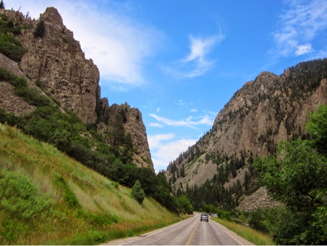
Rain soothed us to sleep and woke us up with the harsh reality that we were destined to ride in it. Our original plan for a route though Kansas was blocked by a huge red and green blob on the radar. So we headed north on 76 to avoid it, but mostly in the hope that we could meet up with some very dear friends. 

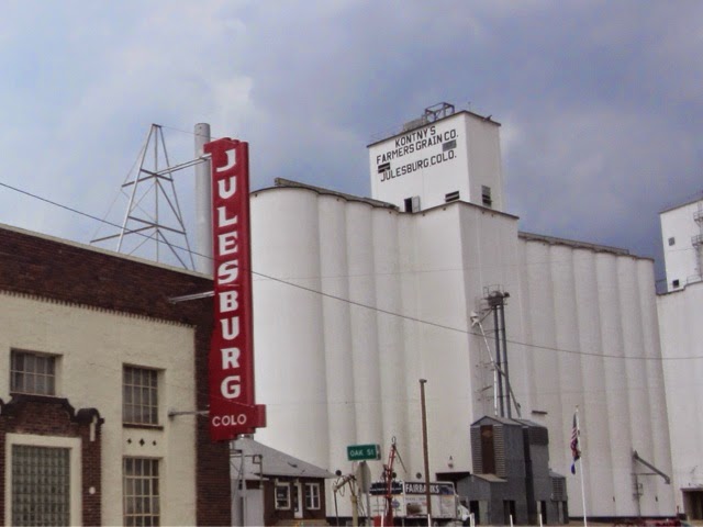
Flashback to three years ago. On a motorcycle cruise to the Caribbean, we met some of the most beautiful people we have ever known : Rob and Robin, Dale and Lorraine from Canada, and Jeff and Kim from Iowa. Numerous attempts to meet up again over the past years have fallen short. But today the cards played in our favor. Emails, Facebook posts and finally a phone call brought some of us together, when a riding group with Rob, Jeff and Kim collided with us at the border of Colorado as we rode east and they rode west. For two very short hours we renewed friendships and made new ones,  ate fried chicken and laughed together all over again in Julesberg, CO. It was golden!

As they rode off to the west to jump into mountain glory, we shouldered into Nebraska on route 80 for a long hike. In reality, it was far more interesting than I had imagined. The scale of farming is incredible and for us, every tractor, farm, irrigation system is an event. We were excited to see haystacks, something from the past. Tractor trailers carrying farm equipment and hay ruled the highway and immaculate, well-farmed cornfields lined the road. Not a bad ride!

Ending our day in Grand Island, we ate dinner surrounded by everything Husker. As soon as you enter this state it is made very apparent that there is only one thing in a Nebraskan's life - football. Every gas station and rest stop flaunts Red. I couldn't help but get the fever while here. 

A day that started out as a grind through pioneer territory, became another highlight on our trip. How wonderful to cross paths with friends from another adventure as we end this one and they continue a new one. Perhaps sometime in the future we will travel together again, but for now, today was an added gift to our growing stash of memories.


Kim and Jeff with their awesome Victory - photo bombed by Rob.


Rob


So who is this town's namesake?


All you can eat fried chicken?


Honestly....


Hay!


Corn as far as you can see!


Tuesday, July 29, 2014

7/29/14 Whipped Cream


Rocky Mountain high today!

 A leisurely wake up turned into a forced disencampment after reading the weather. Used to the afternoon storms, we were bludgeoned with a report of serious weather heading our way in the morning. Out the door with two other bikers who forsook their Bloody Mary's in lieu of a dry ride, we all headed toward the king of national parks, Rocky Mountain.

Grand Lake passed with its boats and vacationers and then we were into my favorite park. Early in, we avoided much traffic and slowly immersed ourselves into the ascent. As always, this park lured us in , lying with each turn that it couldn't get better.

Because it was our last dance with the best partner in America, we held it tight and melted closely into each curve. Swaying into the altitude, we defied rain clouds and pretended this would never end. Each peak paled in comparison to the next and then we were riding in unison with some of the tallest mountains in our country. Snow crowded onto the road, adding a chilling reality. The Rockies have been a dessert to our fabulous trip, and today was the whipped cream. We lapped up every bite and yearned for more.

Into the Big Thompson Canyon, we silently savored the end of a paradise. One of my favorite rides, this canyon is carved by a trout fisherman's heaven that can become deadly. As we rode through, we began to see changes from our last trip. One of our favorite places to stay was closed, cabins destroyed. Huge chunks were carved out of the canyon's walls and houses hung precariously off cliffs. Evidence of a destructive flood was everywhere, including a new road. Last September a usual afternoon rainfall turned into a deluge and flash flooding filled the canyon. With nowhere else to go, the water took out all that was in its path. Flash flood warnings have been posted all week and this made it very real.

Leaving the canyon, we abruptly left the Rockies. Flatlanded, we longingly stared at the disappearing mountains in the rear view mirror as the temperature rose. Molting rain suits and leather, we headed toward Loveland and the desert of Colorado. Yet, in this weather pattern, the desert is also getting drenched with much needed rain. Running on route 34, we skirted storms for hours, but our paths collided at Fort Morgan where we put in for the night and watched the sheets of rain wash the desert clean.

The denouement has begun. Always satisfying, but also sad, we look back at our days in the clouds. Colorado was the climax of an amazing climb from the extraordinary to the sublime. Back into reality, we enter a productive part of the states.  Instead of snowy peaks and heart stopping passes, oil and cattle begin to fill our vista. Vital to the economy, they are far more important than a thrill ride up a mountain pass, but the thrill ride is vital to our lives and we will take it for all it's worth, for as long as we can.


Top of the Rockies


Let's make tracks!


The Big Thompson


The canyon


Flood damage


Canyon walls


So much storm wind, we picked up some tumbleweed!


7/28/14 A 5 Pass Day

Even in my best years, I've never had so many passes in one day.

A euphoric wake up to a Rocky Mountain sunrise defined our morning. Since our breath wasn't stolen enough, we decided to ride to Leadville, having the highest altitude of an incorporated town in the US at 10,200'. Continuing on route 24, part of The Top of the Rockies Byway, we met the Tennessee, Pass, our first of the day. We viewed stately Mt Elbert, and several lead mines, one perched precariously on a cliff, along with a small town. Our second pass of the day was Trout Creek, elevation 9,487' - a piece of cake! Our ears were popping like corn.

Route 24 ended right after Minturn, a cute little town, and dumped us on 70. Past Vail, we climbed the Vail Pass, nice and easy for trucks and traffic. At Siverthorne we branched off onto route 6 to tackle the Loveland Pass. Much more challenging than the first three, Jules and Rascal worked beautifully together, rolling into the 180s, cut into the mountain to get us up the hill. At 11,990', our highest pass of the day. Snow still clings to mountain and avalanche warnings are posted. As we climbed, the weather began its daily descent from perfect to perfectly ugly. Eyes to the sky, I watched as dark rain filled clouds moved to the earth all around us, but we stayed dry.

Back on 70 for a short jaunt, we left the traffic for Route 40. A stop for lunch in Empire at The Original Hard Rock Cafe gave us a history lesson and a great meal. Open since 1934, it was named for the hard rock miners who frequented and used it as a bunkhouse. Now it houses the cafe, an antique store, the town hall and police station. As we were enjoying our lunch I tried to avoid eye contact with the darkening sky, but that didn't make it any better. Just as we left the restaurant, the skies opened up and we barely had time to get the bike under the overhang at the gas station across the street before the hail came. 

Coloradans love this rain. They have been under a drought for several years and these showers are replenishing their water. But this was no shower - it was a deluge. Then, true to these afternoon storms, it was over in 30 minutes, but not trusting the sky, we suited up to ride on. 

Our last climb of the day was over Berthoud Pass. Notoriously difficult because of its height, 11,307', and numerous switchbacks, Jules handled it like a pro, slaloming through the curves with the grace of a skier.

Not only did we do the passes today, we also followed the ski trail. Snowmass, Vail, Copper Mountain, Breckenridge, Keystone, Winter Park and many other smaller slopes appeared, green squiggles down mountains where some snow still stands. I can just imagine the excitement in these areas when the air cools and the afternoon rain showers turn to snow.

At the mouth of Rocky Mountain National Park, we called it a day in Granby as the rain dumped on us again. Tomorrow is our final play date with these mountains and then we will decompress as we leave the altitude. Breathless from the elevation and allure of the Rockies, we have spent days with our heads in the clouds, spinning out memories on twisted roads. Crisscrossing the Continental Divide, we have seen the birth of rivers like the Rio Grande and Arkansas and witnessed geological miracles. It will be difficult to leave, but sooner or later we must breathe again.


Good morning Rockies


Leaving beautiful Twin Lakes


The Arkansas


Rain delay


The Original Hard Rock Cafe


In for the night


Sunday, July 27, 2014

7/27/14 Just Passing Through

It's always about the ride and not the destination. In theory, we are supposed to be heading home. In reality, we will take whatever road is the best, no matter what the direction. 

Today we headed due west, to run the edge of the Black Canyon of the Gunnison, because it was a ride we just couldn't do without. Rimming this deep dark canyon, Route 92 follows geology and we flew above the river. Mythically carved ebony walls knifed down into an abyss thousands of feet below. For miles we followed the gorge, zigging the zag created by the river. Then the road dipped down toward a  grassy inlet where we crossed to rise yet again on the other side. Vertigo seized me as I stared over the unguarded edge to the river below. This is a bucket list road and just because we've fulfilled it, doesn't mean we won't be back again.

We stopped at Crawford State Park for lunch and got nailed by another lonely senior volunteering to watch the park. Russ filled us in on all the water info of the area. The drought in Colorado has ended here as they had record snows . Not so everywhere else. He really wanted us to camp there because he had no one else to talk to, but we suctioned off from him - not easily. 

Following the West Elk Loop, we turned onto 133 at Hotchkiss. All of these roads defy description. If you look at a map, the convoluted paths that they take show the mountain passes and descents. Too many to name, some just have a warning at the top about the upcoming down grade. A maze of mapping, we followed as many as we could. Passing through coal country, we headed into Carbondale, aptly named. Built by coal, this town's proximity to Aspen has it preening a bit too much.

Soon, Ferraris and Lamborghinis  began to ride with us. We were heading into the town that defines the word presumptuous. The airport was lined with private jets and we were rife with attitude. Blasting Lady Gaga's "The Fame", we rode through Aspen proclaiming our ordinariness. 

Faced with a dilemma, we didn't take long to make a decision. We were here only to ride Independence Pass, one of the most challenging motorcycle roads in these mountains. The afternoon storm clouds had settled into the pass and hunkered there menacingly. This pass in the rain is more than treacherous - we know from prior experience. But the choice between an evening in  pomposity and a 12,000' ascent into the maelstrom was a no brainer. We flew out of Aspen like we had been propelled from a sling shot.

In T-Shirts, we gained altitude with some sun. The tricky switchbacks around blind mountain walls were challenging, but at least we were dry. Thrilled with our flight from Aspen, the decreasing temperature didn't affect us. Higher we rose, following a pioneer trail that makes one wonder why they ever tried. The meadows were thousands of feet below and the summit was still miles away. Gathering storm clouds chilled us even further and by the time we reached the top of the pass, reality trumped euphoria. Time to put some clothes on, including rain gear.

I can't describe the trip down because over the pass, it immediately began to rain - hard! With my head down to escape the needles, I saw nothing but the road. Amazingly, great music kept us rockin'.
We had solace in knowing that there was an old hotel in Twin Lakes, a tiny settlement at the bottom of the pass, where we had stayed before. Drenched, we slogged in the door, only to find they were full, and apparently the other two places here were also. Dejected, we were about to leave to ride 20 miles in the rain to the next town. Then, an angel ran up to us to say there was an opening in the road house next door.

A spa-like room, complete with fluffy bathrobes is our port in the storm. A gourmet meal next door in a crowded dining room proves that Aspen is leaching over the mountain. We talked to a local biker who had come in to shelter from the rain. He said that when he was a kid, Aspen was like Silverton, one paved road through the middle of town. Change is inevitable, but that doesn't mean one has to like it.

Surrounded by some of the tallest peaks in the Rockies, we sleep at 9,000 feet tonight. Away from the rat race on the other side of the hill, I once again thank Jules, my guide and savior, for seeing us out of the doldrums, through the storm and into safe haven. 


Morrow Point reservoir


The Black Canyon of the Gunnison


This picture makes my knees weak


All the closer I would get


Gunnison selfie


Not a bad view for a picnic


Canyon walls


Crowded Aspen


Up into the clouds on Independence Pass


The Meadows


We made it!


Rain suit on!


The wet descent


7/26/14 Threading the Needle


True to its name, the Silver Thread Highway threaded us through the rain today.

An early start form Durango, saw us out on route 160 in beautiful weather.  Riding into the Ute Reservation, we passed Chimney Rock. A national landmark created by erosion, the stony formation juts into the skyline . We paused here to appreciate this oddity.

Into the San Juan Forest again, we began a lovely ride of ascents and descents into Pagosa Springs. Here we headed north on route 148, the Silver Thread Scenic Byway. Loosely following the Rio Grande to its roots, the road is scenic, historic and a mighty fine ride.

We stopped for lunch in a campground planted by the river. Clear skies had given way to fluffy clouds and now as we got into the mountains these cotton balls had picked up all the moisture they could handle and were angry and dark, exploding everywhere. Thunder echoed from the mountains as we watched a storm roil toward us, trying to ruin our picnic. But we stared it down, rejoicing in its shade, and watched it head away. Just as we were relaxing, a clap of thunder from behind announced another boomer rolling in. So we packed up. 

On the way out of the campground we met Melvin, the camp attendant. Many retired people spend their summers in RV's watching over these state parks. A low talker, Melvin had us listening intently to his stories of being a football coach and teacher, told in his Texas drawl. He assured us that the road to Lake City tracked right between these two storms and we wouldn't get wet. A friendly man in this lonely spot, he seemed hungry for conversation.

So we threaded the storms. Following the river, the road took us through Creede, a once thriving town built on silver, with a population of 10,000. Now boasting a population of 400, the town exists on tourist trade. Once the home of Bat Masterson, Calamity Jane and Bob Ford ( the killer of Jesse James who was shot here himself), Creede is kept alive by tourists who come to immerse themselves in its history.

At the Slumgullion Pass between Creede and Lake City, we were given a modern geological lesson. The Slumgullion Earthflow began 850 years ago when an earthquake ripped out the top of the mountain. About two hundred years ago, the earth began to move again. The red dirt still continues to flow at approximately 20 ' a year. An active geological site! We looked for movement and were glad we saw none, because we had to ride right under it. The flow got its name because it looked the unappetizing stew prospectors used to make. 

From this pass we could also view the massive mountain range peaked by the Uncompahgre Peak. The Rio Grande Pyramid on the other side of the divide is the birthplace of the grand river that flows from here for 1850 miles to the Gulf of Mexico. Surrounded by such grandeur, we failed to notice that our thread through the storms began to disappear.

Lake City sits on Lake San Cristobal, the result of the earthquake and ground movement at Slumgullion. After passing through here, we picked up the Gunnison River and followed it to our home for the night. Pursued by thunderclouds, we were rained on briefly, but soon dried off in the next patch of sun. The Gunnison cuts deeply into the rock, creating beautiful canyons that we followed to the city of Gunnison where we rest for the night. Even on our dinner trek out to the Gunnysack Cowboy Bistro, the rain threatened us, but we rode there and back unscathed. At 7700' we are sleeping in our highest elevation of the trip. Breathe!

Getting home dry in the Rockies is a crap shoot. We have learned to disregard the ominous clouds, claps of thunder and darting lightening. There is no planning with these fickle storms that pop up every day and everywhere, sucking up the heat and laying down cool green moisture. Some days, like today, we are lucky and feel confident in our good fortune. But, our rain suits are always packed on top for the next foray into the clouds.


Chimney Rock


Our ride


The Rio Grande


Our picnic spot by the Rio Grande


Our picnic friend


The Rio Grande starts out as a stream through meadows


The Uncompahgre


The Slumgullion Slide


We ride under the slide


Creede


An abandoned silver mine


The Gunnison


An antique steam tractor